OpenStreetMap Importer
OpenStreetMap is an open format, crowd sourced mapping resource available from OpenStreetMap.org. Please review the license terms before using OSM data.
The options are to start a new project by importing a map from OpenStreetMap or to import an OpenStreetMap into an existing project.
Import using a Template 
To create a new project importing an OpenStreetMap file, go to the New Project tab and zoom in to the place of interest.
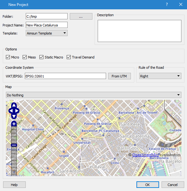
Select the desired template. By default when Aimsun Next is installed, four templates customized for OSM are provided in 4 languages. The Coordinate System will be set automatically as a projected UTM zone using WGS 84.
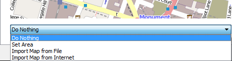
Before creating the new network, an import option must be selected:
- Do nothing: no import, just load the model template as it is.
- Set Area: no import, load the model template and zoom to the area (and set the UTM zone) corresponding to the map.
- Import Area from the Internet: import the visible map from OSM servers, zoom to it, and set the UTM zone. Note that OSM servers will not allow import of large areas.
- Import Area from File: Import the visible map from an OSM file. filter the data outside the visible map, zoom to the area, and set the UTM zone.
The last option requires that an OSM file has been downloaded, probably from OSM Planet. This site provides maps by country and, sometimes, by region. When using this option, Aimsun Next will filter objects outside the visible map.For example use the map of Germany to import an area in Berlin. Note that loading and filtering large OSM files will require a lot of CPU power and RAM.
The OSM Importer dialog box will then come up as shown below:

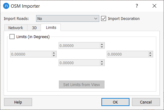
The map can be used to create a draft network Import Road: As a Network or to import extra objects for decoration purposes select Import Decoration.
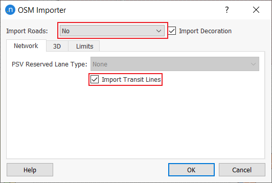
It is also possible to use the map to decorate an existing network (importing parks, buildings, lakes…) without adding any traffic network element. In this case select the option Import Roads: No.
Select the option Import Transit Lines to create transit lines along with the created network.
OSM can hold information on the attributes of objects, the canonical list of OSM attribute tags is found at OSM Map Features This can include land use as well as travel network information.
Import into an Existing Model 
To add information from an OpenStreetMap to an existing Aimsun project, select the File : Import : OpenStreetMap Files option or the File : Import : OpenStreetMap from Internet option.
If the option to import from a file is taken, after the file is selected, the dialog with the import options will appear.
If the option to import from the Internet is selected, the file is downloaded using the bounding box of the current model and the same importer options are applied.
If the co-ordinate systems of the current OSM import and the existing model are different, the details of the two systems are presented and a choice which to use as the future model co-ordinate system.
If importing an OpenStreetMap file to a project that was not originally created with an OSM template and also importing sections with their OSM road type, first edit the External ID of the Road types that the new sections will belong to. The Road Type’s external ID should contain the following words:
- motorway
- trunk
- primary
- secondary
- tertiary
- residential
- pedestrian
- rail
- tram
- subway
- unclassified
For all OSM sections with a road type defined that is not present in the project, the default road type will be assigned.
OSM 3D Import
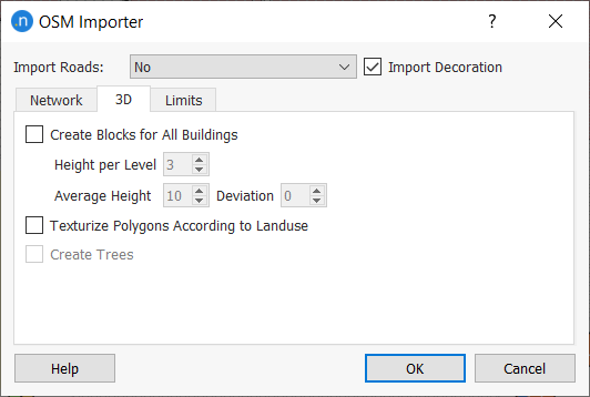
In the 3D section of the OSM Importer dialog, several options can be set up to allow Aimsun Next to take advantage of this additional information, if provided by OSM, and build a more detailed scene for 3D rendering. The following options are available:
- Create Blocks for all Buildings. Aimsun Next will create buildings with the height that OSM provides it with. When no height data is provided, a flat polygon will be created instead. With this option enabled, the user can create building with varying heights. This gives a much realistic look of urban areas in the 3D View.
- Texturize Polygons According to Land Use. With this option enabled, Aimsun Next will add textures to polygons created for known Land Uses such as parks and forest.
- Create Trees. With this option enabled, Aimsun Next will randomly place 3D models of trees over areas marked as “wood” or “forest” in their Land Use attribute.
OSM Transit Import
Notes regarding the importation process:
- Transit data includes lines and their stops. Timetables are not included.
- Transit lines and stops are located in the layer OpenStreetMap/Transit.
- External id of transit stops or lines refer to the node or relation id in the OSM file.
- Transit stops overlapped are merged into a single stop. External id of this stop contains the id of every stop merged.
- Multiple transit lines are created when the original line is not connected internally. These lines have the same name with an extra identifying number referring to the order of the original line.
- Transit data can be imported into an already created network. Select Import Roads: No and Import Transit Lines. Decoration does not affect the process.
- Information about the OSM format imported can be found here OSM Buses.