WMS Importer
WMS (Web Map Service) is a protocol for serving geo-referenced map images from a server which gathers its data from GIS or other sources. The WMS service was developed by the Open Geospatial Consortium. WMS servers are provided by numerous data services, linked to crowd sourced data, commercial data or to data provided by national and international organizations.
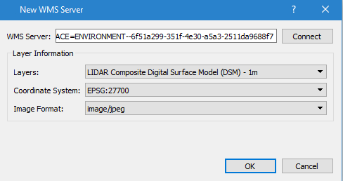
Add a new WMS server using the Tools menu, Add WMS Server option. The WMS server URL is obtained from the information provider and can include the parameter request=GetCapabilities although this will be added if it is not provided in the URL, Connecting to the server will download a list of layers with their co-ordinate systems and image formats. Click OK to add a layer from the WMS server to the list of layers in the model shown in the Layers Window.

Activating that layer in the Layers Window will then include the images sourced from the WMS server in the 2D display. To stop receiving the images deselect the layer in the Layers Window and to remove the server, delete the layers associated with it.